
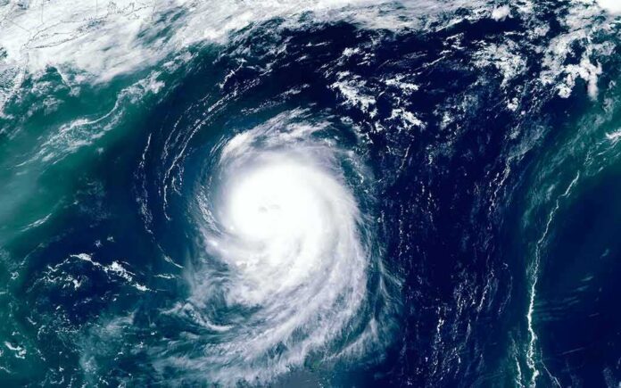
A so-called “death band” flashed across Hurricane Polo’s flank just as the storm held Category 4 power, and that eerie look had a real engine behind it.
Story Snapshot
- Hurricane Polo held Category 4 strength with 150 mph winds off Mexico’s Pacific coast.
- NOAA products showed rapid strengthening and classic major-hurricane structure.
- The viral “death band” likely reflected eyewall and rainband changes common in powerful storms.
- Outer bands brought heavy rain to southwest Mexico while the center stayed offshore.
Category 4 Power With A Menacing Look
The National Hurricane Center reported Polo’s maximum sustained winds near 150 miles per hour, squarely in Category 4, with room to wobble stronger before a later weakening trend. Satellite analysts at the National Oceanic and Atmospheric Administration logged the storm’s rapid ramp-up and tight core, a signature of a mature major hurricane. Media and hobbyists focused on a bulging arc along one side—the “death band”—but the headline fact stayed the same: Polo packed dangerous wind, rain, and surf for Mexico’s west coast, even while offshore.
The phrase “death band” is not an official term, but the shape struck nerves for a reason. Strong hurricanes often grow odd layers and rings when their inner core changes. Those rings can mean shifting size, a wider wind field, and fresh bursts of heavy rain. That is why forecasters warned coastal Mexico about flooding rain and rough seas from outer bands while the center remained over water. The look was dramatic; the hazards were practical and close to home.
What That Strange Band Likely Means
Forecasters described eyewall replacement and intensity swings around this time window, a dance that can reshape a storm’s face on satellite. In powerful hurricanes, a new outer eyewall can form, tighten, and choke the old one. The result can be a bulging ring or band that seems to “pop” visually, even as peak winds dip a bit and the storm’s wind field spreads out. Research shows these cycles are routine in major hurricanes and can repeat more than once during a storm’s life.
That visual shift cuts both ways for risk. Peak winds near the eye may ease for hours, but the area that feels strong winds and heavy rain can grow. That tradeoff matters for people on shore. A wider wind field pushes larger waves and longer swells. Outer bands can stall and dump rain far from the center. The storm might look “weird,” but the impacts grow more widespread, not less.
Hazard Over Hype: What To Watch
The National Hurricane Center stressed clear, testable facts: wind speed, motion, rain threats, and surf hazards. Those details drive decisions that keep people safe. The “death band” label came from social media and headlines, which often reward shock value. That hype can grab attention, but it can also blur what matters most: where the rain bands go next, how the wind field expands, and when seas get dangerous for boaters and low-lying areas. The conservative, common-sense view here is simple: focus on verified hazards, not catchy names.
#17E Hurricane #POLO
Satellite: #NOAA21 #JPSS2 #VIIRS
Channel : Day/Night Band DNB (0.7 µm) 375-m
Time : 2026/09/25 0846Z
Data Source : Amazon S3 Bucket SDR
CPA : ~30 km pic.twitter.com/VxrTQDh6dl— Ben (@zeb199818) September 25, 2026
Mexico’s southwest coast saw rain as Polo tracked offshore, and forecasters expected more bands to swing inland as the storm evolved. Guidance hinted Polo could pulse in strength near-term, then gradually weaken as conditions changed around it. That path still leaves risk in its wake. River rises lag the rain. Mudslides can follow after soils saturate. Long-period swells can batter beaches long after the radar eye drifts west. People do not need a viral nickname to respect that timeline.
Why The Eye Plays Tricks On Us
Human brains are wired to react to striking images, and hurricanes offer plenty. A tight eye invites awe; a bulging outer ring looks ominous. In reality, the physics stay grounded. As hot water fuels towering storms, the core often reorganizes. A fresh eyewall forms outside the old one, steals its fuel, and slowly takes over. Wind peaks may dip during the swap, but the storm’s reach can grow. That is what the band likely signaled here: structure in motion, not a new kind of storm.
Forecast offices have improved at threading this needle. They let satellites do the showmanship while they deliver crisp, local hazard calls. That balance is the model to follow as Polo spins on. Check the official updates for track and timing. Heed local alerts for rain, wind, surf, and slide risk. Share the dramatic clips if you must—but act on the boring parts. Those are the parts that save lives.
Sources:
nypost.com, goes.noaa.gov, nhc.noaa.gov, nytimes.com, cnn.com, yahoo.com
© partiallypolitics.com 2026. All rights reserved.