New Jersey’s shore went underwater and the lights went out as a slow, tide-driven nor’easter met a full moon and onshore winds.
Story Snapshot
- The governor declared a state of emergency in eight counties before the worst surge hit.
- Forecasters warned of strong winds, heavy rain, and significant coastal flooding through the weekend.
- Thousands lost power as floodwaters rose across multiple shore towns.
- High tides and a full moon amplified back-bay flooding and beach erosion.
Emergency Declared For Eight Counties As Surge Built
Governor Mikie Sherrill declared a state of emergency for Atlantic, Burlington, Cape May, Cumberland, Middlesex, Monmouth, Ocean, and Salem counties. The order took effect at 5 p.m. Friday, September 25, 2026, to speed resources and keep roads clear for first responders. The move targeted the coast and the bays, where water stacks up fast. It also cued local leaders to prepare for round-after-round high tides. That timing mattered once onshore winds locked in.
State messaging set clear expectations. Officials warned of strong winds, heavy rain, significant coastal flooding, and hazardous conditions along the coast and inland. They also said the most severe impacts would build Friday night and continue through Sunday. That window matched the tide cycles that drive coastal flooding. It also gave towns a short runway to move trucks, stage barricades, and warn residents in low spots. The risk picture was not vague; it was specific and time-bound.
Power Outages Grew As Wind And Water Cut Lines
Utilities reported thousands without power as the storm intensified Friday night into Saturday morning. Patch later logged outage counts by company, with Jersey Central Power and Light leading the totals and other providers showing smaller but notable impacts. These numbers jumped with each tide and wind burst, then eased as crews restored circuits. Exact statewide totals moved with the dashboard time stamps, but the pattern was plain: trees, saturated ground, and salt spray meant lights out for many.
Restoration followed the usual order: public safety first, major lines next, then neighborhoods. That triage works because it restores the most people fastest. It also aligns with conservative common sense: protect life, clear roads, and get critical systems back. Crews cannot climb wet poles in gale gusts, so some delays were baked in. The real test comes after the blow, when access improves and bucket trucks can safely rise.
Flooding Hit Known Hot Spots In Repeating Tidal Pulses
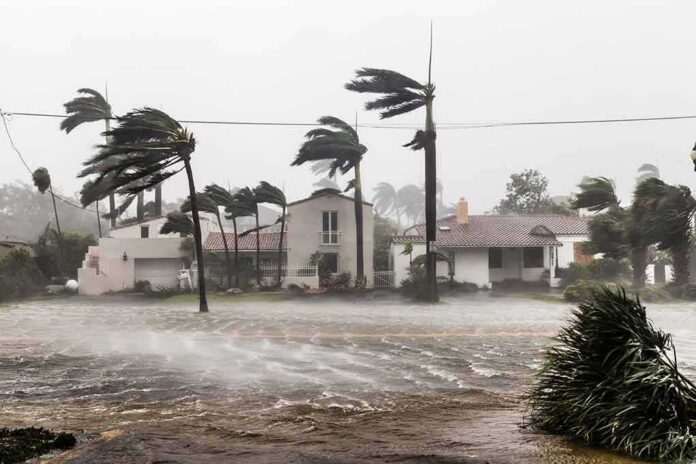
Reporters on the ground showed water where people park, drive, and live. In Seabright, a lot and an adjacent street flooded, one car was stranded, and firefighters pulled a woman and her dog to safety. Long Beach Island saw submerged roads and homes taking on water. Manasquan and Atlantic City dealt with heavy waves and back-bay flooding as the wind held water in the bays. These scenes returned with each high tide, then receded, then returned again.
The mechanics were familiar but potent. A full moon raised the base tide. Persistent onshore wind pushed water toward the coast and into back bays. A slow-moving system kept the setup in place long enough for repeated peaks. Forecast teams flagged coastal flood advisories, called out the worst tide windows, and noted large waves off Barnegat. That is why local flooding felt worse late at night and near dawn. The clock and the sky worked together.
Why Preparation Mattered And What Comes Next
The emergency declaration gave counties and towns freedom to move faster and coordinate across lines. That is the right call when tides, wind, and power risk stack up. Residents got direct signals to lift cars, avoid flood-prone roads, and expect outages. Businesses along the bays had time to board doors and pull stock. One caveat remains: live outage totals and impact snapshots can shift as the storm breathes in and out. The broader damage count often lands days later.
US Nor Easter Live updates via New York Times: High winds and exceptionally high tides 🌊caused flooding ⚠️in low-lying areas along Jersey Shore and in some coastal parts of NYC🗽, submerging streets, cars and first floors of some buildings. https://t.co/PagvTDyUrU #climate #News pic.twitter.com/P6CHGQ2usR
— EnviroEdgeNews (@EnviroEdgeNews) September 26, 2026
New Jersey has seen this script before, and it will see it again. Nor’easters repeat. Tides rise. Bays fill. The lesson is not panic; it is discipline. Park high. Respect road closures. Keep a basic kit. Push the state and utilities to harden lines and lift key gear in flood zones. That is prudent stewardship and good governance. The coast will always call people to live and work there. The smart response is to meet water with foresight, not surprise.
Sources:
feedpress.me, foxweather.com, newjersey.news12.com, patch.com, abc7ny.com
© partiallypolitics.com 2026. All rights reserved.